Conquer the Spectacular Paso Internacional Los Libertadores: Chile-Argentina Border Crossing
Chile and Argentina share more than 5,000 miles of border, most of them drawn on the imposing peaks of the Andes. With over 40 border crossings between the two countries spread over the mountains, the most spectacular is Paso Internacional Los Libertadores, also known as Paso del Cristo Redentor.
Is Paso de los Libertadores paved?
The road to the summit is entirely paved. It’s called Ruta 60 (in Chile) and Ruta Nacional 7 (in Argentina). The border is actually a 3,080 meters long tunnel: the Cristo Redentor tunnel: 1,564m are in Chilean territory and 1,516 on the Argentine side. Opened in 1980, the tunnel sits at 3,175 m (10,417 ft) above sea level. The name of the tunnel comes from the 4-ton Christ the Redeemer of the Andes (Cristo Redentor de los Andes) statue placed in 1904 near the entrance of the Argentine side at an elevation of 3,832m (12,572ft) above sea level. It is the most important step between the capital of Chile, Santiago, and the Mendoza region of Argentina.
Is Paso de los Libertadores open?
Set high in the Andes, the road can be closed during winter because of heavy snows blocking both ends and the threat of rockfall. The snow, together with the nature of the road, requires extreme patience and skill to negotiate.
Is the road to Paso de los Libertadores difficult?
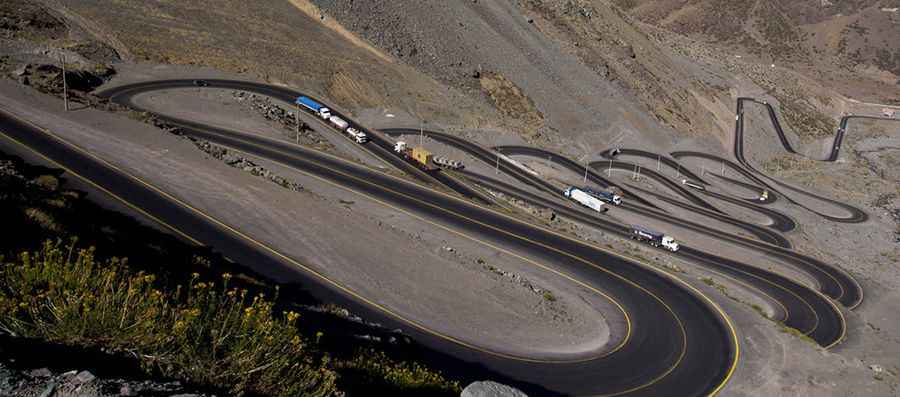
The Argentinian road (RN7) turns out to be a gentle ascent, up relaxed through rugged mountain scenery of the area until the hole in the tunnel entrance. Extreme patience and skill are the key, and the adrenaline rush and thin air make for a thrilling, if occasionally slow, driving experience. Wind can also slow things down, but conquer all that and you'll be rewarded by magnificent views of the switchbacks below and South America’s highest peak, Aconcagua. The Chilean side of the road (Ruta 60) is very difficult to navigate through one of the most winding routes in the world, giving the appearance of the coil of a fridge from the air. It features one of the most scenic drives globally on a short section known as Los Caracoles (the snails). It’s a terrible steep climb featuring more than 20 hairpin turns. Los Caracoles is a series of hard switchbacks on an extremely steep incline. Access by the Chilean side is harder than on the Argentine side. The landscape remains the same, but the road gets higher much more quickly, forcing a winding route so perfectly delineated that, seen from the air, it looks like the coil of a refrigerator. Traffic is intense, especially for heavy vehicles facing this part with calmness and resignation, forming long convoys that slow pace, amounting to a bottleneck. Viewed from a distance, the trucks seem like snails.
Is Paso de los Libertadores dangerous?
The road through the summit is maintained quite regularly and does not have a morbid accident record. The road is covered with snow for most of the year; still, traffic is intense; cargo trucks and even double-decker tourist buses travel the road on a daily basis year-round, forming long, slow convoys, hence the name. Despite being one of the most challenging roads globally, The pass has a strong safety record. With intense traffic, especially full of slow-moving heavy vehicles, accidents are rife. Not only that, for a vast proportion of the year, the road is covered in snow, requiring severe caution at all times. There are no guardrails.
Pic: www.planetatriatlon.com