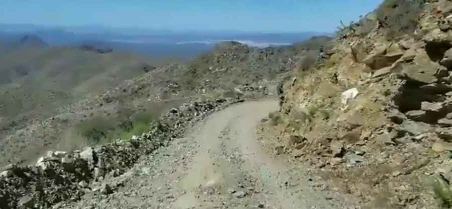
If you have a fear of heights, the road to Harquahala Mountain is not for you
Harquahala Mountain is a high mountain peak at an elevation of 1.732m (5,681ft) above the sea level, located on the boundary between La Paz and Maricopa counties, in the south-central part of the U.S. state of Arizona.

Located west of Phoenix, the road to the summit, South Western Arizona’s highest peak, is totally unpaved. It’s called Harquahala Back Country Byway (Harquahala Mountain Summit Road).
How long is the road to Harquahala Mountain?
The challenging road to the very windy summit is very rugged and steep in places. It’s 16.89km (10,5 miles) long. The road is graded and wide at the bottom, but the upper parts are narrow, steep and rocky. This road is single lane only and meeting another vehicle would truly put both drivers ‘between a rock and hard place’. This rugged drive to the top is not for the faint of heart. If you have a fear of heights, hairpin curves, steep drop offs and a lot of rocky jouncing and jostling which will bounce you around like a ping pong ball, you had better stroke this destination off your list. 4-wheel drive, high-clearance vehicles required.
Is the road to Harquahala Mountain steep?
The road to the summit is really steep, hitting a 30% of gradient through some of the ramps and the elevation gain is around 4,000 feet. The summit hosts the Harquahala Smithsonian Observatory, built by the Smithsonian in 1920 to measure and record solar activity. It was abandoned in 1925 and in 1975 was listed on the National Register of Historic Places and has since been stabilized. The summit is the highest point in southwest Arizona with breathtaking 360 degrees vistas. On a good day the views can be extraordinary. One could see the Four Peaks east of Phoenix, Hualapai Peak just south of Kingman, Signal Peak and all the way down to Yuma, the Colorado river basin and clear into California. Even today, the vistas are usually clear, free of air pollution. For the history buff, the drive displays old mining debris, shafts and stone houses from earlier miners.
Is the road to Harquahala Mountain open?
The rugged and challenging road is typically open all year round, with the occasional closure in winters due to dangerous weather conditions. It is best in the fall, winter and spring. It is very hot in the summer. Do not drive if snow has fallen on the summit or if lightning threatens. Do not attempt this trail in the summer where temperatures of 100 plus degrees are the norm. The BLM warns of the risks of abandoned mines, “rattlesnakes or other poisonous creatures,” and sudden “violent and dangerous” thunderstorms. You will find no facilities. You have to go fully prepared to be self-sufficient.
Pic&video: Nomad Overland