
Million Dollar Highway is the most beautiful road of America
In the US state of Colorado, there’s a special highway built in the late 1880s: the Million Dollar Highway. It's one of the nation’s most spectacular drives. You'll be on the "outside" for a while with a hell of a view to your right (let the passenger enjoy the view. You'll want to watch the road). Forget standard driving safety measures like guardrails and shoulders.
Death Road in Bolivia is the world's most famous gravel track
Carretera de los Yungas is probably the most famous road in the world. This gravel dirt track covers a 36.4km (22.61 miles) stretch between La Paz and Coroico, in the Yungas area of the Bolivian department of La Paz. Known globally as the "Death Road," it is a place where engineering limits meet raw human fear.

The Atlantic Road of Norway Is a Scenic Coastal Drive on the Edge of the Sea
Tucked away in the midwest part of the Norwegian coastline, the coastal Atlantic Road is one of the most scenic drives in the world. Driving along this road is like teetering on the edge of the sea. The curvy road dips and arches over the brutal waves of the Norwegian Sea that often crash over the pavement during storms. This unique highway will bring you out to the very farthest point where the land ends and the ocean begins.

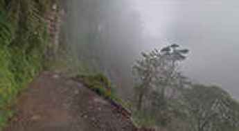
Skippers Canyon Road is New Zealand's Unbelievably Scary and Historic Drive
Tucked away on the southwest of New Zealand's South Island, Skippers Canyon Road is now one of New Zealand's better-known scenic roads and is unbelievably scary, being extremely narrow and difficult to maneuver. It’s a road so dangerous that your rental car insurance won’t be honored if you drive on it.
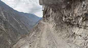
Driving the Treacherous Fairy Meadows Road in Pakistan
Fairy Meadows Road is a spectacular and perilous high mountain track located in the Gilgit-Baltistan region of Pakistan. The unpaved road is completely unmaintained, with no guardrails to protect you, and it gets so narrow that near the end, you’ll have to cover the last section by walking or biking.

Conquering the D915 (Bayburt-Of): Turkey's Most Extreme Road
The D915 is one of the world's most challenging roads. Located between the Black Sea and the Northeast Anatolia regions of Turkey, it is known for its dangerous terrain. Only experienced drivers should attempt this route, as any mistake can have serious consequences.

Conquering the Legendary Kahekili Highway in Maui
Kahekili Highway is a strip of one-lane paved road framed by rock on one side and sheer cliff drops on the other, with a length of 21 miles, running from Kapalua to Wailuku. It’s a legendary road known for its snaking turns, narrow passages, and dangerous road conditions, though nowadays that last factor is gone, since the road was completely repaved not too long ago.

Iron Mountain Road: 17 Miles, 314 Curves, 14 Switchbacks, 3 Pigtails, and 3 Tunnels
Iron Mountain Road is a demanding 17-mile scenic drive located in the Black Hills of South Dakota, featuring 314 curves, 14 switchbacks, 3 tunnels, and 3 pigtails (turns that loop over their own road, allowing the road to climb rapidly).
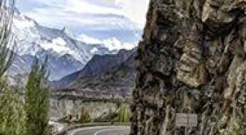
Karakoram Highway is the highest paved international road and Eighth Wonder of the World
The Karakoram Highway (informally known as the KKH) is said to be the highest paved international road in the world, running between Western China and Pakistan. It's the road to paradise for those who love exploring the mountains, offering a once-in-a-lifetime road trip for adventure lovers.

Black Bear Pass is a high mountain adventure in the Colorado Rockies
Located in San Miguel County in the U.S. state of Colorado, Black Bear Pass is a high mountain pass at an elevation of 3,915m (12,844ft) above sea level. It's one of the highest roads in Colorado.

The winding Tail of the Dragon in North Carolina: 318 curves in 11 miles
Straddling Tennessee and North Carolina in the USA, Deals Gap, also known as Tail of the Dragon, is one of the most scenic drives in the USA. Featuring 318 curves, this winding mountain road is unlike anywhere else in the world.

Explore the Legendary Shafer Trail Road in Utah's Canyonlands National Park
Shafer Trail Road, also known as Potash Road, is an iconic drive located on the east-central edge of Utah in the western United States. Extreme caution is required, especially in inclement weather and at night, for both vehicles and mountain bikes. At times, the road is so narrow that only one car can pass.

Discover the Beauty of Engineer Pass: Colorado's High Mountain Off-Road Adventure
Engineer Pass is a high mountain pass at an elevation of 3,901m (12,800ft) above sea level, located in Ouray County, in the U.S. state of Colorado. It’s mostly a first-gear ride because the road is rough and rocky. It's one of the highest roads in Colorado.
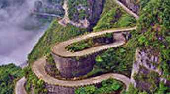
Tian Men Shan Big Gate is the road with 99 turns
Tian Men Shan Big Gate Road is a winding drive with 99 turns located in Tianmen Mountain National Park of China. From its construction in 1998 to the 11-kilometer journey, this road offers a unique experience.

Exploring the Breathtaking Beartooth Highway: A Scenic Adventure
The Beartooth Highway is a thrilling adventure. Part of the U.S. Highway 212, the road offers stunning views of the Absaroka and Beartooth Mountains. This spectacular mountain road spans Wyoming and Montana and climbs up to 10,964 feet above sea level. It’s one of the highest roads in Wyoming and Montana.

Furka Pass is the Alpine road for James Bond
Furka Pass is a high mountain pass at an elevation of 2.431m (7,976ft) above sea level, located in one of the snowiest regions in Switzerland. It’s one of the world's most iconic, exhilarating and exciting drives through the Swiss Alps. The pass was immortalized by the Aston DB5 / Ford Mustang car chase in James Bond's Goldfinger. It’s one of the most famous Alpine roads of Switzerland.

Moki Dugway is a breathtaking Utah off-road adventure
Part of Utah Route 261, Moki (or Mokee) Dugway is a stunning, graded dirt switchback road carved into the face of the cliff edge of Cedar Mesa. It consists of 3 miles of steep, unpaved but well-graded switchbacks (11% grade), winding 1,200 feet from Cedar Mesa to the valley floor near Valley of the Gods.

Oh-My-God Road is a thrilling adventure in Colorado
Oh-My-God Road is a very exciting drive located on the boundary between Clear Creek and Gilpin counties, in the U.S. state of Colorado. With room enough for barely two cars to pass slowly, this road will surely feel a little dangerous to you.

Conquer Bealach na Bà: Scotland's Most Scenic and Challenging Mountain Road
Bealach na Bà is a winding mountain road located in the Applecross peninsula, in the Scottish Highlands. It's renowned as one of the most scenic drives in the world, and speeds faster than 30 mph are rarely permitted.

Leh-Manali Highway is an epic journey across the Roof of the World
Embark on a journey through the Himalayas with the Leh-Manali Highway. This mountain road, known for its challenges, takes us through some of the world's highest passes. From its strategic importance to the day-to-day life around it, we'll explore the key aspects of this iconic route. Join us in unraveling the story of the Leh-Manali Highway—a testament to both engineering and the raw beauty of the landscapes it traverses.

Col du Chaussy: Conquer 17 Breathtaking Alpine Hairpins on This Scenic French Pass
Col du Chaussy is a high mountain pass at an elevation of 1,533m (5,029ft) above sea level, located in the Savoie department, in the Rhône-Alpes region of France. The road to the summit starts with the famous “Lacets de Montvernier,” a special 3 km stretch with 17 hairpins as the road virtually climbs a cliff. It's an improbable road clinging to the edge of the cliff, making it one of the most scenic drives in the world.