Strada delle 52 Gallerie is a WWI military mule road
Strada delle 52 Gallerie (Road of 52 Galleries) is a military trail built during World War I on the massif of Pasubio in Italy. The track was constructed in this position to stay away from Austro-Hungarian artillery fire, with its pinnacles, deep canyons, and sheer rock faces.
Why was Strada delle 52 Gallerie built?
Straddling Trentino-South Tyrol and Veneto in Italy, this trail crossed the area of Pasubio and was the theater of a series of bloody battles. For this reason, it was christened the "Sacred Area of Italy," in remembrance of the many soldiers who died there. Along the trail, many memories of these tragic wartime events are preserved, including the Road of Heroes, which was almost entirely excavated in the rock to allow supplies to be brought to the Pasubio front from behind the lines, protected from Austrian artillery fire. Troop movements, protection, and dominance of the strategically important valley below were the reasons for such a challenging undertaking. Its implementation had strategic importance because it allowed communication and supply from the back to the summit area of the Italian Pasubio, where ran the first line of enemy fire and the shelter throughout the year, unlike the stock of Scarubbi, accessible by motorized vehicles but in conditions far more hazardous under the blows of the Austrian guns, and only during the summer.
How long are the 52 tunnels in Italy?
The road, also known as the 52 Tunnel Road, is 5.3 km (3.29 miles) long, running west-east from Bocchetta di Campiglia to both Strada degli Eroi and Strada degli Scarubbi. What makes it famous are the stunning views, and the legend says that you can’t just go there only once. The true surprise that people most often don’t expect when coming to this place is the huge difference in temperature from the bottom to the top, and even from halfway to the top.
When was Strada delle 52 Gallerie built?
Set high in the Pasubio mountain range, the road was a masterpiece of military engineering (built by the Italian Army with the help of six centuries of workers), considering the conditions and the times in which it was constructed, and the rapidity of performance: Work began on February 6, 1917, and concluded in November 1917. It was considered a military engineering marvel and was constructed in just 10 months under the guidance of Lieutenant Joseph Zappa. Its implementation was of great strategic importance because it allowed communication and transfer of supplies from the base to the summit area of Mt.Pasubio. During the First World War, the front line between the Italian and Austro-Hungarian forces ran through the Dolomites. Monte Pasubio was a crucial stronghold for the Italians. They had to hold the mountain, but their supply lines to the mountain were being shelled and were subject to avalanches [on one day, the 13th December 1916, known as 'White Friday', 10,000 soldiers were killed by avalanches in the Dolomites]. The answer to the Italian Army's problems was the Strada delle 52 Gallerie. Key aspects of the road include year-round access, located outside of enemy artillery range and accessible by mule.
Why is it called Strada delle 52 Gallerie?
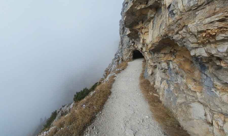
The road is 5.3 km (3.29 miles) long, of which 2,280 are classified into 52 rock galleries. Each gallery is numbered and marked by its own name. About 2.5 kilometers of the trail are through tunnels - numbered and named - ranging from the shortest at 10 meters long to the longest, number 19, at 318 meters long. The tunnels are at least 2 meters (6 feet) wide and all are at least as tall to accommodate a mule, so they are relatively comfortable to walk through unless you have severe claustrophobia. The tunnels vary considerably in length. The longest one is over 300m long. There are a few short ones but many in the 40-90m range. A good torch [plus a spare and batteries is essential]. There are long stretches of tunnel where it is pitch black. You will not need a helmet. You will be ascending [sometimes steeply] pretty much all the time. Only the last two tunnels slope down. In some of the tunnels the path is smooth. In others, it is very uneven. Water drips down from some tunnel roofs and makes the path slippery. At the end of the Strada, you arrive at Refuge Achille Papa where you can eat and drink. The minimum width of 2.20 m was originally intended to allow the transit of contemporary two mules with their baggage. Characteristic of the many galleries is the 19-th because besides being the longest (320 m), it has a helical path to 4 turns, within a giant tower of rock. The next N. 20 is excavated in a rock tower, and to overcome the significant difference is screwed on itself like a corkscrew. The stretch from the 41-th to the 45-th runs in the Fountain Golden Pass (1,875 m). Upon exiting the 47-th to reach the highest point of the road (2,000 m), where you can enjoy a magnificent panorama.
Each tunnel is numbered and characterized by a particular name.
| Order | Name of tunnel | Length (meters) |
| 1 | Cap. Zappa | 17 |
| 2 | Gen. D'Havet | 65 |
| 3 | Rovereto | 14 |
| 4 | Battisti | 31 |
| 5 | Oberdan | 10 |
| 6 | Trieste | 17 |
| 7 | Gen. Cascino | 35 |
| 8 | Gen. Cantore | 23 |
| 9 | Gen. Zoppi | 78 |
| 10 | Sauro | 12 |
| 11 | Magg. Randaccio | 28 |
| 12 | Cap. Motti | 95 |
| 13 | Cap. Filzi | 27 |
| 14 | Cap. Melchiori | 61 |
| 15 | Tortona | 45 |
| 16 | Reggio Calabria | 74 |
| 17 | Bergamo | 52 |
| 18 | Parma | 46 |
| 19 | Re | 318 |
| 20 | Gen. Cadorna | 86 |
| 21 | Gen. Porro | 20 |
| 22 | Breganze | 8 |
| 23 | Gen. Capello | 18 |
| 24 | Bologna | 16 |
| 25 | Aquila | 11 |
| 26 | Napoli | 24 |
| 27 | Cap. Picone | 98 |
| 28 | Genova | 14 |
| 29 | Spezia | 31 |
| 30 | Miss | 10 |
| 31 | Gen. Papa | 72 |
| 32 | Palazzolo | 48 |
| 33 | 33ª minatori | 57 |
| 34 | Gen. Giustetti | 132 |
| 35 | Trani | 10 |
| 36 | Gen. Garibaldi | 12 |
| 37 | Balilla | 26 |
| 38 | Torino | 29 |
| 39 | Mantova | 53 |
| 40 | Trento | 10 |
| 41 | 26ª minatori | 24 |
| 42 | Macerata | 19 |
| 43 | Polesine | 55 |
| 44 | Zappatori Liguria | 22 |
| 45 | Plotone 25ª minatori | 83 |
| 46 | Piceno | 65 |
| 47 | Pallanza | 22 |
| 48 | Cesena | 14 |
| 49 | Soldato italiano | 19 |
| 50 | Cav. Vittorio Veneto | 27 |
| 51 | Plotone minatori sardo | 66 |
| 52 | Sardegna | 86 |
Is Strada delle 52 Gallerie open to vehicles?
The road, also known as Strada della Prima Armata, has scary tunnels, hair-raising cliffs, and splendid scenic views. If you are too much into a speed craze and even take your eye out of the road, bear in mind your life is at maximum risk. The road is closed to vehicles as it is dangerously narrow and slippery, spanning many cliff faces and tunnels with stunning scenery, making this a popular destination for adventurous travelers. The cars were prohibited some years ago due to the number of fatal accidents. The authorities have erected barriers at either end to stop bikers, but it would be possible to pass bikes over the barriers. However, someone would have to be very silly to do the Strada as a mountain bike ride. It would be too dangerous and too much hard work for little benefit.
Is Strada delle 52 Gallerie worth it?
It is one of the best high-level paths in the Dolomites, and walking it is a memorable experience. The road, now converted to a hiking trail, is a hit with trekkers and mountain bikers admiring the stunning views, cliff drops, and mountain tunnels. Never underestimate this track! Strada delle 52 gallerie is also the starting point of 2 very challenging old military roads in the zone: Strada degli Scarubbi and Strada degli Eroi. There is an information board at the start of the walk, with a small section in English. Each tunnel is numbered and at intervals there are more boards giving information on the next few tunnels.
Is Strada delle 52 Gallerie dangerous?
It shouldn’t be attempted in the winter because of dangerous conditions and the possibility of snow blocking the tunnels. A headlamp or a flashlight is a necessity. The road is totally closed to vehicles, but some of the locals still flaunt the rules and use it to access the guesthouses in the area. There are some parts of the trail that drop off on the side, but the trail is pretty wide so it's not so scary. Going back down can be tricky because the tunnels can get slippery.
Pic: Filippo Crosara