Col du Chaussy: Conquer 17 Breathtaking Alpine Hairpins on This Scenic French Pass
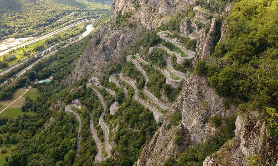
Col du Chaussy is a high mountain pass at an elevation of 1,533m (5,029ft) above sea level, located in the Savoie department, in the Rhône-Alpes region of France. The road to the summit starts with the famous “Lacets de Montvernier,” a special 3 km stretch with 17 hairpins as the road virtually climbs a cliff. It's an improbable road clinging to the edge of the cliff, making it one of the most scenic drives in the world.
Is the road to Col du Chaussy paved?
The challenging winding road to the summit is entirely paved. It's called D77B. It climbs sharply via 17 hairpins tightly stacked one on top of another in just 3km. Dating from 1934, Col du Chaussy is probably best known for the truly unbelievable hairpins at the start – the “Lacets de Montvernier,” an astonishing piece of mountain road engineering. But beyond this, it’s a significant climb with more than 1000 meters of ascent.
Is Col du Chaussy challenging?
In the mountains, when the road is not wide enough to allow two vehicles to pass, the vehicle going up has priority over the one going down. If the crossing requires a reverse, then the most maneuverable vehicle has to achieve it. Uphill, choose the 3rd or 4th gear, not more. Downhill, use your engine brake, even until 2nd downshift before starting a tight turn. Through a series of 17 tight corners, drivers will beat a vertical drop of 400 meters in just 3 miles away. The mountain is exactly where you do not want your brakes to fail. Before leaving, check the brake fluid level and the condition of your pads. It’s one of the lesser-known climbs in France, but the road is like no other in the Alps. The bendy section is concentrated within a 2.5km stretch, meaning a bend every 150 meters. This is the steepest part. After the hairpins, it’s still a very interesting climb winding up through alpine fields with a great stretch along a cliff road a few kms from the top. The road continues with quite a regular slope (7-8%), passing through the villages of Le Noirey, Montbrunal, and Montpascal. The southern side of the road is entirely paved but very narrow. The last kilometers before the summit are badly surfaced.
Is the road to Col du Chaussy steep?
Starting from La Chambre, the ascent is 14.4 km long. Over this distance, the elevation gain is 1,062 meters, and the average percentage is 7.4%. And from Pontamafrey, the ascent is 14 km long. Over this distance, the elevation gain is 1,031 meters, and the average percentage is 7.4%.
When was the road to Col du Chaussy built?
Tucked away in the southeastern part of the country, the drive is actually quite scenic. If you don’t focus only on the tarmac in front of you, you may see the ruins of an old castle. Not less than 6 years of work between 1928 and 1934 were necessary to defeat the 400 meters of ascent to connect the valley to the village of Montvernier. These small laces, stacked over each other, clinging to the mountain road, are one of the most spectacular in the area and a real challenge for cyclists. The upper section goes through several villages and offers panoramic views of the Belledonne Mountains.
Is the road to Col du Chaussy worthwhile?
This road, a hair-raising lane cut into the sides of sheer cliffs, is one of the most famous balcony roads in the country. It's not for those who fear heights, as there is little room for error. Looking at those photos, it's normal for your palms to sweat; imagine what it must have been like before the barriers. If you can handle the height and the prospect of a very long free fall, this road absolutely has to be on the list of any road connoisseur. There are not many roads like this in Europe.
Pic: Frédéric Prayer