Assietta Road: Driving the legendary military ridge track of the Western Alps
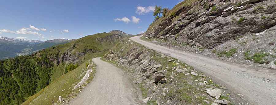
Strada dell'Assietta (SP173) is a spectacular military carriageway running along the mountain ridge in the Metropolitan City of Turin, northern Piedmont. This historic route connects Pian dell’Alpe to Sestriere, staying almost entirely above 2,000 meters and offering one of the most iconic high-altitude driving experiences in the Italian Alps.
| Road facts: Strada dell'Assietta (SP173) | |
|---|---|
| Location | Piedmont, Italy (Cottian Alps) |
| Length | 39.3 km (24.23 miles) |
| Max Elevation | 2,615 m (8,579 ft) |
| Min Elevation | ~2,000 m (Sustained ridge) |
| Surface | Unpaved / Gravel and Rock |
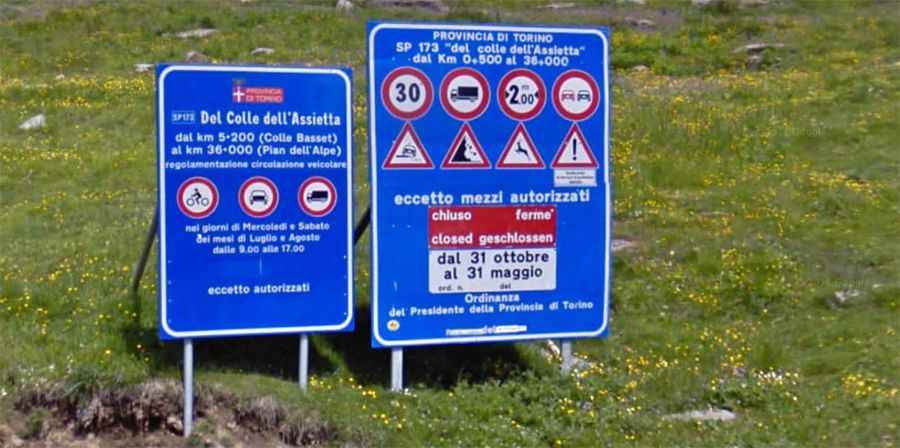
| Restrictions | Max width 2m / Weight 3.5t |
How long is the Assietta Road?
The road, officially designated as Strada provinciale 173 del Colle dell'Assietta, is 39.3 km (24.23 miles) long and remains mostly unpaved. This high-altitude track can be traveled in two main ways, connecting Sauze d'Oulx to the famous Colle delle Finestre. The military road follows the jagged ridge separating the Val Chisone from the Val Susa, developing for over 30 kilometers within the protected boundaries of the Gran Bosco di Salbertrand Park. Driving here is a unique opportunity to explore a territory where high-mountain nature meets significant European military history.
When was the Assietta Road built?
The origins of the Assietta road date back to the late 19th century. It was commissioned by the Kingdom of Italy military commanders in 1890 to allow for the rapid movement of troops and artillery between the Chisone and Susa valleys. The project was meticulously planned by combat engineers in 1889. Today, the strategic importance of this route is still visible through the ruins of several forts, barracks, and defensive walls that dot the landscape along the ridge.
Is the Assietta Road worth the drive?
Absolutely. The road offers some of the most sweeping panoramic views in the Western Alps and represents a true challenge for drivers. It is a shared space used by motorized vehicles, mountain bikers, hikers, and horseback excursionists. To protect its fragile environment and ensure safety, local authorities promote a “smooth” and respectful circulation. It is an incredible historical and environmental itinerary, attracting hundreds of passionate travelers every year, particularly from Germany, who seek the silence and the artistic and natural heritage of these high-altitude peaks.
Is the Assietta Road open and what are the schedules?
Due to its extreme altitude, the road is only accessible during a short summer window, typically from June 1st to October 31st. Strict transit regulations apply: vehicles must not exceed 3.5 tons in weight or 2 meters in width. To improve the experience for non-motorized users, the road is closed to motor vehicles on Wednesdays and Saturdays during July and August. The highest point of the entire route is reached at Monte Gran Costa (2,615 m), providing an unrivaled vantage point over the Alps. For real-time updates on closures, it is recommended to check the official website at www.stradadellassietta.it.
Along the route, you will summit several legendary mountain passes:
- Colle dell'Assietta (2.474 m)
- Colle Lauson (2.497m)
- Colle Blegier (2.381 m)
- Colle di Costa Piana (2.313 m)
- Colle Bourget (2.299 m)
- Colle Basset (2.424 m)
- Monte Gran Costa (2.615m)
Is the Assietta Road difficult to drive?
The road is demanding and requires high concentration. It often cuts along exposed cliff faces where only a low stone wall separates the vehicle from steep drops into the valley. The surface is completely unpaved and can be heavily deteriorated in certain sections, with loose rocks and deep ruts, especially in the sharp curves. There is a strict speed limit of 30 km/h, and it is strictly forbidden to overtake or stop outside the designated parking areas. A vehicle with good ground clearance is highly recommended to navigate the rocky terrain safely.