Rohtang La Drive: Exploring the Road through the Dead Bodies Pass in the Himalayas
Rohtang Pass is a high mountain pass at an elevation of 3,979m (13,054ft) above sea level, located in Himachal Pradesh, a northern Indian state in the Himalayas.

Where is Rohtang La?
Set high on the eastern Pir Panjal Range of the Himalayas, the pass is situated about 53 km from Manali. It connects Kullu valley with Lahaul and Spiti, which in turn provide access to Leh.
Can you drive through Rohtang La?
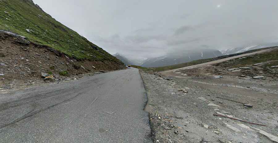
The road to the summit is the infamous Leh-Manali Highway. It’s 479 km (298 miles) long, running from Leh (in Ladakh in Jammu and Kashmir state) to Manali (in Himachal Pradesh state). The road has been improved in recent years. Currently, it’s mostly paved. The road is so dangerous that the Government of India is building an 8.8km tunnel as an alternative to bypass the summit.
What is Rohtang Pass famous for?
Known for its scenic beauty, Rohtang Pass, also known as Rohtam Pass, holds strategic importance for India. This pass is an ancient trade route between the people on either side of Pir Panjal. The move to control traffic was also necessary as the area beyond Rohtang Pass (Lahul and Spiti valley) gets connected by road for only three months (July to September) in a year given the rough weather conditions. This is the time when people from Lahul valley transport their cash crop, potatoes, and peas to the markets across Rohtang Pass to Kullu and earn money for the landlocked period of 9 months the rest of the year. As the vehicle climbs higher on the road, the beauty of the landscape around will leave you awestruck.
Is Rohtang Pass dangerous?
The road is in dreadful condition and requires strong nerves to negotiate it. It remains off-limits from the rest of the country for over five months due to heavy snow deposits on the road. It is one of India’s most dangerous roads, which can be a challenge for any vehicle to pass through. Winding bends, steep drops down with no barrier, rock falls, and landslides all create a recipe for disaster. The pass has become infamous for long traffic snarls with jams, at times lasting for 12 long hours. The road remains jam-packed, and delays are inevitable. Traffic jams are common as military vehicles, trucks, and goods carriers try to navigate the tight roads and rough terrain, compounded by snow and ice at certain points and the large number of tourist vehicles. A long queue of tourist vehicles has become a daily scene on this stretch. Rohtang Pass figures high on itineraries of tourists visiting Manali, Kullu, Leh, and nearby areas. Besides Lahaul and Spiti, Rohtang Pass also serves as the gateway to Pangi and the valley of Leh. Like the Zoji La Pass, Rohtang also serves as the gateway to Ladakh. The pass offers beautiful sights of glaciers, peaks, Lahaul Valley, and the Chandra River. The twin peaks of Geypan are also visible from Rohtang.
In which month is Rohtang Pass closed?
In winters, the pass remains closed but is open from June to October for motor vehicles. This road is usually open from May to November, but it can be closed anytime when the access is not cleared of snow. Every new season, the road crew has to struggle with their GPS to dig out the road buried under the layers of snow. However, massive and deadly landslides continue, giving the pass its name, which translates to the ground of corpses. The temperature begins to fall with every meter you go higher. Especially hazardous is Rani Nallah, which has remained a major bottleneck when traveling to the pass. It’s situated 6 km before Rohtang Pass and has become a major irritant for tourists and travelers while reaching the pass due to bad road conditions. The area has become a constant sliding zone for the past few years. The ordeal at Rani Nallah starts once the snow starts melting during the summer season. The melting snow turns this 2 km stretch into a nightmare for motorists. The entire stretch will be full of slush and mud. There is no respite later with the advent of the monsoon season. With rains and the constant sliding of the hillside, the road gets fully covered with slush. The best time to visit the pass is between May/June to October/November. In May, it becomes a hotspot for adventure enthusiasts.
What is the meaning of Rohtang?
The name Rohtang means ‘ground of corpses’ or ‘pile of dead bodies’ due to the number of people who lost their lives trying to cross it. The road is certainly breathtaking. The pass sits on the watershed between the water basins of the Chenab River and the Beas River, and offers beautiful sights of glaciers, peaks, Lahaul Valley, and the Chandra River. The twin peaks of Geypan are also visible from Rohtang. Presently, no vehicles are allowed to cross this stretch between 8 am to 12 pm daily as the BRO makes this stretch motorable. Due to the military significance of the highway and the need to keep it open the entire year, the Indian government began building the 8.5 km (5.3 mi) long Atal Tunnel (Rohtang Tunnel) in 2010 to bypass Rohtang pass for creating a much safer and faster year-around link.
Pic: Anisch Lolayekar