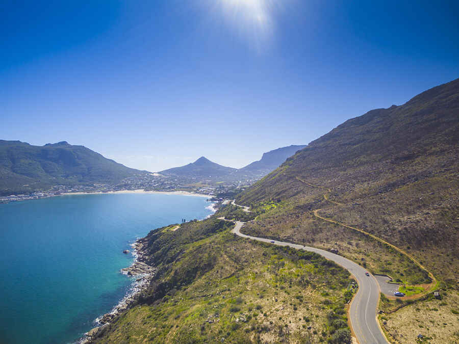
Chapman’s Peak Drive is one of the world's most spectacular coastal drives
Located on South Africa's Atlantic Coast, Chapman’s Peak Drive ranks among the world's most breathtaking coastal drives, offering unparalleled scenic beauty and thrilling twists along the way.

Where is Chapman's Peak Drive located?
The road is situated in South Africa's Western Cape province, at the south-western tip of the country, on the Atlantic Coast. The route skirts the rocky coastline of Chapman’s Peak (593m), which is the southerly extension of Constantiaberg and is a great hike for the energetically inclined.
When was Chapman's Peak Drive built?
It was built between 1915 and 1922 with the use of convict labour. The road was regarded as a major feat of engineering. A rockfall in 1990 caused the closure of the road, but it was reopened in 2003. Although the road was closed intermittently for a decade or so due to safety concerns related to rockfalls, a thorough civil engineering revamp saw the road reopen in late 2009.
How long is Chapman's Peak Drive?
The toll road, part of the M6, is 9km (5.59 miles) long, running north-south from Hout Bay to Noordhoek. The twisting road is totally paved and has 114 curves. It was hacked into the near-vertical face of the mountain on the western side of the Cape Peninsula.
How long does it take to drive Chapman's Peak Drive?
It's one of the most scenic drives in the world. To drive the road without stopping will take most people between 20 and 25 minutes. It’s necessary to drive slowly and cautiously – all the better to gaze out at the spectacular vistas. Flanked by both the towering mountainside and sheer drops into the Atlantic Ocean below, Chapman’s Peak Drive is a nail-biting route passing through a number of picnic spots and whale-watching vantage points that offer respite from the hair-raising drive. The maximum speed limit is 40km/h and don’t stop on the yellow lines as the narrow roads can be dangerous otherwise.
Is Chapman's Peak Drive open?
The road, affectionately known as “Chappies,” is only closed as a precaution in the event of severe wind or rain. Landslides can close the road.
How much is Chapman's Peak Drive?
Since 2005, it has been a toll road. Visit the official website to know the toll tariffs. Originally known as the Hout Bay - Noordhoek Road, some say it is one of the most spectacular marine drives in the world.
Is Chapman's Peak Drive worth it?
This short road is widely regarded as one of the most scenic stretches of road anywhere in the world and offers stunning 180º views of the western side of the Cape Peninsula. Its 114 curves mean the five miles will require some attentive driving, but with views like this, it’s well worth it. This beautiful road overlooks the sea and feels like you’re traveling alongside a mountain’s edge. Cape Town's Chapman's Peak Drive is all about the scenery. Overlooking Noordhoek and Hout Bay, this rocky coastal roadway offers numerous points at which motorists can safely pull over and savour a panoramic view across the deep-blue waters of the Atlantic Ocean and the shapely shoreline that meets it. From stunning vantage points, some of which are up to 593m above sea level, it is not uncommon to see whales and dolphins frolicking in the ocean below, and baboon troops curiously observing passing tourists. This is a perfect place from which to take stunning photographs of the Cape. This incredible road stretches alongside Chapman’s Peak, a mountain located on the western side of the Cape Peninsula, south of Cape Town. 'Chappies' is local speak for Chapman’s Peak Drive, one of Cape Town‘s most famous landmarks. There are many areas along the route where you can stop and take in the exquisite scenery or sit down for a relaxing picnic.
Image credit: Depositphotos